Good to know
- Vehicle accessible - strictly 4wd only
- River crossing required to access, only cross if flows are safe to do so. Seek local knowledge before attempting
- Seasonal camping area, drive to the conditions and follow any road closures
- No facilities available
- Portable toilet required
- Campfires not permitted
- No dogs allowed
- Sheep and cattle may graze this area
Activities
- Dispersed camping
- Walking
- Fishing
Camping area description
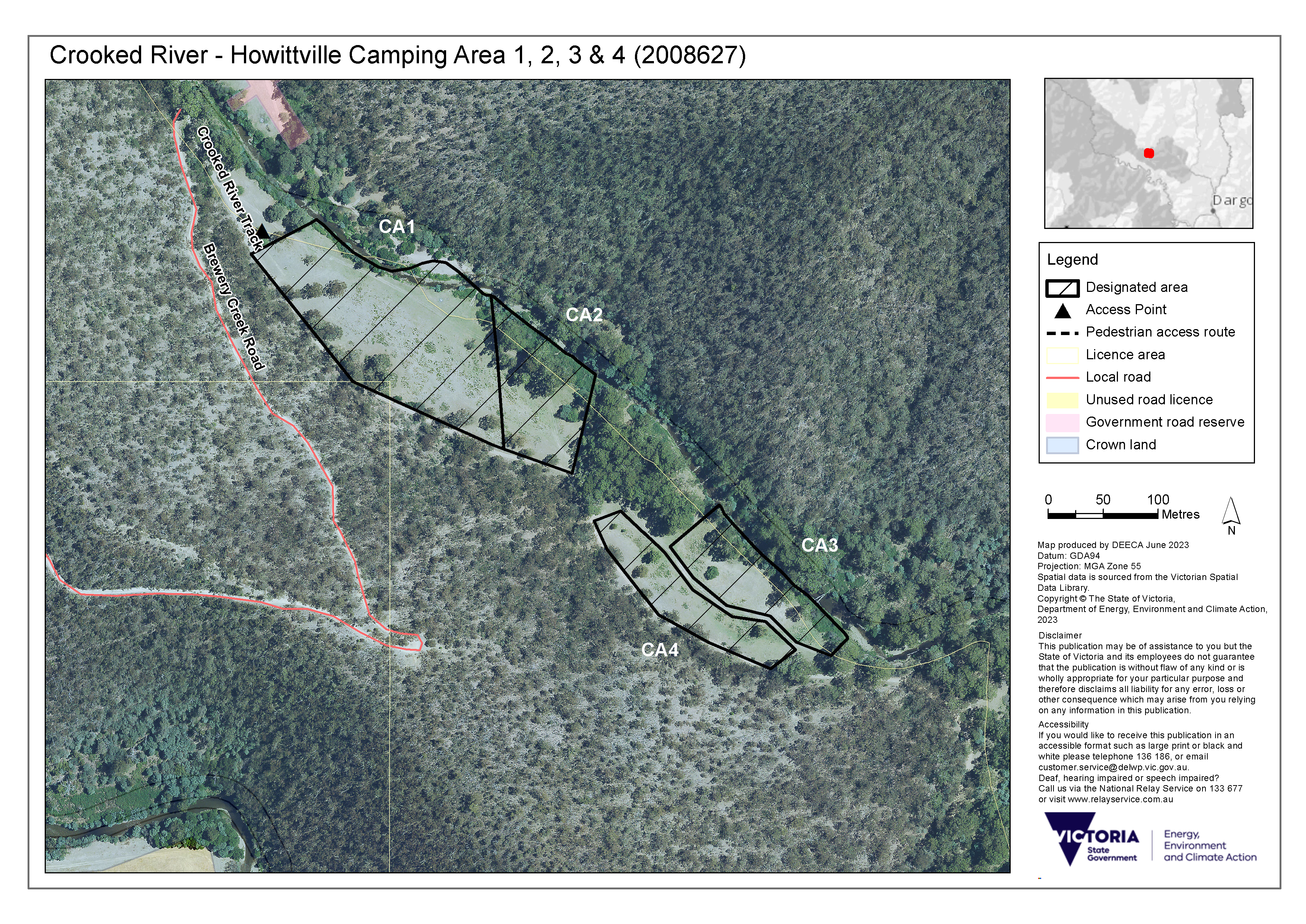
The Crooked River - Howittville camping area 1, 2, 3 and 4 provides for camping and fishing on the banks of the Crooked River, approximately 44 km north-west of the Dargo Fire Shed. Vehicle access is from Crooked River Track (refer to the map below).
This camping area is on a licensed Crown water frontage that has been designated for camping. Before visiting this site, find out about camping on licensed Crown water frontages.
The camping area is mostly flat. It is important that campers take care to use the map and instructions below to safely access the area and avoid trespassing on private property.
Camping is only permitted in the designated area on this frontage (see map below). Visitors may use other areas of Crown water frontage for recreational activities other than camping such as fishing, walking, and picnicking.
Safety
Crown water frontages are rough and rugged bush camp areas. Before you go, it is important to consider all potential risks and hazards when accessing and camping at this location. Campers are responsible for their own safety and the safety of those in their care.
Tree hazard
- Trees and limbs may fall unexpectedly. Avoid camping under trees.
- Stormy and windy weather increases the risk that trees and limbs may fall.
Livestock
- This site may be part of a working farm
- Cattle may be present on this water frontage and access the river.
- If cattle approach you, avoid sudden movements and loud noises.
- Farm animals are not pets. They can be large and unpredictable and should not be approached.
- Store your food in a secure container to avoid attracting livestock and other animals.
- Leave all gates as you find them.
Water and flood safety
- Play it safe by the water.
- Hidden dangers may include submerged objects and debris and strong currents. A storm well upstream from you could cause flash flooding.
- Check the Bureau of Meteorology for weather forecasts and flood warnings, or visit Play it Safe by the Water for more information.
Bushfires
- Be aware of dangerous weather and bushfire conditions.
- Check VicEmergency for information about current fires, Fire Danger Ratings and Total Fire Bans.
Other risks that may be present include dangerous terrain, animals and adjoining farming operations.
How to get there
There are two possible routes to the camping areas. Both require one or more river crossings and subject to local conditions
Option 1:
- From Dargo Hotel, travel south on Lind Ave for 1 km
- Lind Ave turns slightly right and becomes Dargo Rd for 4.8km (note: all these roads are seasonal and subject to closure)
- Keep right to continue on Shortcut Rd for 2.3 km
- Turn right onto Wonnangatta Rd for 21.2 km
- Turn right onto Talbotville Rd for 6.1 km
- Turn left to continue onto Crooked River Track for 900 m
- Turn left onto Randalls Track for 350 m
- Continue onto Crooked River Track for 4.7 km
- Turn right to stay on Crooked River Track for 2.9 km
- The official parking area is on the right before crossing Crooked River and entering the Talbotville historic camping area
- The camping areas are along the Crooked River for approximately 700 m before arriving at the parking area
Option 2:
- From Dargo Hotel, travel north on Lind Ave for 1.4 km
- Continue onto Dargo High Plains Rd for 15.3 kms
- Turn left onto McMillan’s Rd and travel for 15.7 kms
- Turn left onto Crooked River Track and follow through river crossing
- Stay left after river crossing and camping areas are 200m on the left
Get directions to the camping area access point
Map - camping area
Resources
- Camping on licensed Crown river frontage (PDF, 174.0 KB)
- Guide to site assessments - Camping on licensed Crown river frontage (PDF, 155.4 KB)
- Crown water frontage: A guide to public access and recreational use (PDF, 200.0 KB)
- Land (Regulated Watercourse Land) Regulations 2021
Further information
- Water frontage licensing
- Summer safety information
- MapshareVic - licensed and unlicensed Crown water frontages and access points can be explored here using the 'Public Land' theme
Page last updated: 25/07/23